

Oxford boundary markers: Opposite Headley Way (1892)

[City coat of arms showing
ox crossing ford]
1 8 9 2
F. W. A N S E L L
M A Y O R
W. S. C A R V E R
S H E R I F F
This stone is outside 238 Headington Road, opposite Headley Way, where the Headington and London Roads meet. It is immediately to the west of the Boundary Brook (underground at this point), which from 1889 to 1929 marked the boundary between Oxford and Headington. It is not a listed structure.
It belongs to the following series of boundary stones that were set up at the time of the Mayor's perambulation of 1892 (the first such inspection to take place after the 1889 Oxford boundary change):
- Canal towpath
- Sunnymead
- Godstow Road bridge
- Hogacre Ditch
- Woodlands Road
- Woodstock Road
- Iffley Meadows
- Port Meadow (probably)
This map shows the new 1889 boundary of the city marked in blue.
Frederick Ansell was Mayor of Oxford in 1891/2, and there was a special perambulation that year.
William Stevens Carver (1859–1917), the Sheriff of Oxford who would also have been named on this stone, was at the time of the 1891 census a 32-year-old accountant & auditor who lived at 7 Longworth Road with his wife Eliza and their three young daughters. He was the City Accountant from 1894 until his death (obituary in the Oxford Journal Illustrated of 26 December 1917, p. 9).
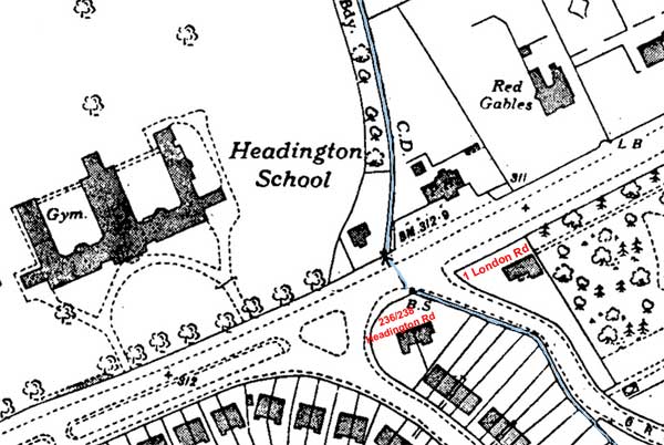
This extract from the 1939 OS map of Headington shows the line of the underground Boundary Brook marked in blue. It crosses spot where the Headington Road meets the London Road (just to the east of the cottage in the south-east corner of Headington School, where Headley Way is now). It then runs through the side garden of 238 Headington Road, and then along the ends of the gardens of the east side of Valentia Road.
Back to list of Oxford
boundary stones