London Road, Headington: number changes
At the west end, the London Road officially starts at the Boundary Brook, which separated Oxford city from Headington from 1889 to 1928 and now runs underground beside the White Horse, emerging on the south side of Old Road.
At the east end the London Road obviously goes all the way to London, but the part deemed to be Headington comes to an end near the Thornhill Park & Ride, at the start of the parish of Forest Hill.
London Road was first numbered following the building of the council estate alongside Barton Road in 1925, but there was a tremendous amount of infilling in the late 1920s and early 1930s as the shopping centre developed, with the result that many of the new shops had no number. The whole road underwent a drastic renumbering in 1934, and the same numbers survive today (with the exception of Sandhill Cottages, which have gone).
L
|
LONDON ROAD: North side, west to east |
|||
| 1911 census | 1921 census |
1933 Kelly's Directory |
1935 Kelly's Directory |
|
| White Horse | White Horse | 1: White Horse | 1: White Horse | |
| Red Gables | 3: Red Gables | Red Gables | 5 | |
| — | — | St Hilliars | 9 | |
| — | — | Dayton | 13 | |
| — | — | Osmington | 15 | |
| — | — | Hovendene | 17 | |
| Here is Sandfield Road | ||||
| — | — | Sandfield House | 19 (Sandfield Guest House) |
|
| — | — | Littlecote | 21 | |
| — | — | Red Mullions | 23 | |
| — | — | The Dial House | 25 | |
| Sandfield Cottage | Sandfield Cottage | Sandfield Cottage | Was No. 43 (now site of Horwood Close) |
|
| [Rose Cottage] | 7 | 7 | 67 | |
| Here is Osler Road (formerly Manor Road) | ||||
| — | — | 9 | 69 | |
| — | — | Walkers's Furniture Stores | 71 | |
| — | — | Rutty, Confectioner | 73 | |
| — | — | Owen, Fruiterer | 75 | |
| — | — | 11 | 77 | |
| 13 | Oak Lodge (formerly the Park Lodge of Headington House) |
79 | ||
| — | 15 | Griffin, watch maker | 81 | |
| — | — | Smith & Tolley cycles | 83 | |
| — | — | Lloyd's Bank | 85 | |
| — | — | Fulkes, oil & colour merchant | 87 | |
| — | Here is Stephen Road (only just laid out in 1921) | |||
| — | — | Burton's Dairies | 89 | |
| — | — | Westminster Bank Ltd | 91 | |
| — | — | 15 | 93 | |
| — | — | 17 | 95 | |
| — | — | 19 | 97 | |
| — | — | 21 | 99 | |
| — | 23 | 23 | 101 | |
| — | 25 | 25 | 103 | |
| — | 27 | [27] Barclays Bank | 105 | |
| Here is Old High Street (formerly High Street, Old Headington) | ||||
| Police Station, 1 Westbourne Terrace |
29 | 29 | 107 | |
| 2 Westbourne Terrace | 31 | 31 | 109 | |
| 3 Westbourne Terrace | 33 | 33 | 111 | |
| 4 Westbourne Terrace | 35 | 35 | 113 | |
| 5 Westbourne Terrace | 37 | 37 | 115 | |
| 6 Westbourne Terrace | 39 | 39 | 117 | |
| 7 Westbourne Terrace | 41 | 41 | 119 | |
| 8 Westbourne Terrace | 43 | 43 | 121 | |
| 9 Westbourne Terrace | 45 | 45 | 123 | |
| 10 Westbourne Terrace | 47 | 47 | 125 | |
| 11 Westbourne Terrace | 49 | 49 | 127 | |
| 12 Westbourne Terrace | 51 | 51 | 129 | |
| 13 Westbourne Terrace | 53 | 53 | 131 | |
| 14 Westbourne Terrace | 55 | 55 | 133 | |
| 15 Westbourne Terrace | 57 | 57 | 135 | |
| 16 Westbourne Terrace | 59 | 59 | 137 | |
| Here is footpath leading to North Place (Bury Knowle lodge and the house itself listed at this point in 1930) |
||||
| — | 61 Bury Knowle Lodge |
61 Cleverly, blacksmith |
207 [now Hedena Health] |
|
| — | 63 | 63 | 209 | |
| — | 65 | 65 | 211 | |
| — | 67 | 67 | 213 | |
| — | 69 | 69 | 215 | |
| Here is footpath leading to Hawthorn Avenue | ||||
| — | 71 | 71 | 217 | |
| — | 73 | 73 | 219 | |
| — | 75 | 75 | 221 | |
| — | 77 | 77 | 223 | |
| — | 79 | 79 | 225 | |
| — | 81 | 81 | 227 | |
| — | 83 | 83 | 229 | |
| — | 85 | 85 | 231 | |
| — | 87 | 87 | 233 | |
| — | 89 | 89 | 235 | |
| — | 91 | 91 | 237 | |
| — | [93] | 93 | 239 | |
| — | 95 | 95 | 241 | |
| — | 97 | 97 | 243 | |
| — | 99 | 99 | 245 | |
| — | 101 | 101 | 247 | |
| — | 103 | 103 | 249 | |
| — | 105 | 105 | 251 | |
| Here is Barton Road | ||||
| — | — | 105A | 253 | |
| — | — | 107 | 257 | |
| — | — | 109 | 259 | |
| — | — | 111 | 261 | |
| — | — | 113 | 263 | |
| — | — | 115 | 265 | |
| — | — | 117 | 267 | |
| — | — | 119 | 269 | |
| — | — | 121 | 271 | |
| — | — | 123 | 273 | |
| — | — | 125 | 275 | |
| Here is Sefton Road | ||||
| — | — | 127 | 279 | |
| — | — | 129 | 281 | |
| — | — | 131 | 283 | |
| — | — | 133 | 285 | |
| — | Currill (shops) |
135 (Currill bootmakers) |
291 & 293 | |
| — | — | 137 (Franklin butcher) |
299 & 301 | |
| Here is Northfield Road | ||||
| — | — | — | 303 | |
| — | No name | 139 | 305 | |
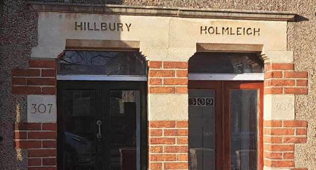
| — | Hillbury | 141 | 307 | |
| — | Holmleigh | 143 | 309 | |
| Here is Bayswater Road (named as Beckley Road in Kelly's Directory for 1930 |
||||
| — | Isolation Hospital | Isolation Hospital, Bayswater Hill |
Not listed | |
| — | Sandhill Cottages | Sandhill Cottages 1 | Sandhill Cottages 1 | |
| — | Sandhill Cottages | Sandhill Cottages 2 | Sandhill Cottages 2 | |
| — | Sandhill Cottages | Sandhill Cottages 3 | Sandhill Cottages 3 | |
| — | Sandhill Cottages | Sandhill Cottages 4 | Sandhill Cottages 4 | |
| — | — | Sandhill House | The Bungalow | |
| — | — | The Dale | 485 (Hillside Boarding Kennels) |
|
| — | — | Windyridge | 487 | |
| — | — | Littlebank | 489 | |
| — | — | Northwood | 491 | |
| — | — | Jesmond | 493 | |
| — | — | Sandhill Warren | 495 | |
LONDON ROAD: South side, west to east |
||||
L
|
1911 census |
1921 census |
1933 Kelly's Directory | 1935 Kelly's Directory |
| — | Lynton House | 2 | ||
| The numbers between 2 and 26 are still unused today | ||||
| Brookside | School, unnamed | Headington School for Girls junior dept |
26 | |
| Here is Latimer Road | ||||
| — | Hillstow Cottage | Hillstow Cottage | ||
| The Lodge | Hillstow Lodge | Hillstow | 42 | |
| Hillstow | Hillstow | 44–58 (Headington Junior School) |
||
| — | — | Stratton | 60 | |
| — | — | Crossway | 62 | |
| — | — | Blen Cott | 64 | |
| — | — | Wilkins Café | 66 | |
| — | — | Watson, ladies' hairdresser | 68 | |
| — | — | Cooper & Boffin, bakers | 70 | |
| — | — | Headington Garage | Headington Garage [= 72] |
|
| Here is Lime Walk [Britannia listed here in the census, but it is actually in Lime Walk, not the] |
||||
| Mount Pleasant | 10 & 12 | 10 & 12 | 74 & 76 | |
| Royal Standard | 14 | 14: beer retailer | 78: Royal Standard | |
| Here is New High Street (formerly High Street, New Headington) | ||||
| Three houses of Belle Vue Terrace and Clifton House listed in this area |
16 | 16 | 80 | |
| 18 | 18 | 82 | ||
| 20 | 20 | 84 | ||
| — | 22 | 86 | ||
| 24 | 24 | 90 | ||
| — | 26 & 28 | 92 & 94 | ||
| Bix | 30 | 30 | 96 | |
| Doctors' house, named in directories as The Cottage |
32 | 32 | 104 | |
| Here is Kennett Road (formerly New Road) | ||||
| Listed without name | 34 | 34 | 108 | |
| Rogate | 36 | 36 | 110 | |
| Foxbury | 38 | 38 | 112 | |
| Wonderklip | 40 | 40 | 114 | |
| The Fir Tree | 42 | 42 | 116 | |
| 118 | ||||
| — | 44 | 44 | 120 | |
| Here is Windmill Road | ||||
| [Part of Co-op] | [Part of Co-op] | 46 | 122 & 124 | |
| 6 Holyoake Terrace | 48 | 48 | 126 | |
| 5 Holyoake Terrace | [50] | 50 | 128 | |
| 4 Holyoake Terrace | 52 | 52 | 130 | |
| 3 Holyoake Terrace | 54 | 54 | 132 | |
| 2 Holyoake Terrace | 56 | 56 | 134 | |
| 1 Holyoake Terrace | 58 | 58 | 136 | |
| — | Here is Holyoake Road, formerly Western Road | |||
| Cycle Works | 60 | 60 | 138 & 140 | |
| Clovelly | 62 | 62 & 62A | 142 | |
| Belmont | 64 | 64 | 144 | |
| 2 Sandmere Villas | 66 | 66 | 146 | |
| 1 Sandmere Villas | 68 | 68 | 148 | |
| No name given | St Kitts | 70 | 150 | |
| — | — | — | 150A | |
| (Funeral path from Quarry] |
Here is Stile Road | |||
| — | — | City Motors Company | 152 | |
| — | — | 72 | [No listing] | |
| — | — | 74 | 156 | |
| Headington National School |
[School] | St Andrew's (C of E) School |
158: St Andrew's (C of E) School |
|
| No houses between the present 158 and 206 until later in the 1930s | ||||
| — | — | 112 | 206 | |
| — | — | 114 | 208 | |
| — | — | 116 | 210 | |
| — | — | 118 | 212 | |
| — | — | 120 | 214 | |
| — | — | 122 | 216 | |
| — | — | 124 | 218 | |
| — | — | 126 | 220 | |
| Here is Ramsay Road | ||||
| — | — | 126A & 126B | 222 | |
| — | — | 128 | 226 | |
| — | — | 130 | 228 | |
| — | — | 132 | 232 | |
| — | — | 134 | 234 | |
| — | — | 138 | 236 | |
| — | — | 140 | 238 | |
| Here is footpath to The Quarry | ||||
| Headington Union Workhouse |
— | Headington Union Poor Law Institution [Workhouse] |
London Road Hospital [now replaced by Douglas Veale House] |
|
| Here is Pitts Road | ||||
| — | [76] | 144 | 264 | |
| — | 78 | 146 | 266 | |
| Seven New Inn Cottages to the west of the New Inn listed here |
80 | 148 | 268 | |
| 82 | 150 | 270 | ||
| 84 | 152 | 272 | ||
| 86 | 154 | 274 | ||
| 88 | 156 | 276 | ||
| 90 | 158 | 278 | ||
| 92 | 160 | 280 | ||
| New Inn | New Inn | 162 | 282 | |
| Seven New Inn Cottages to the east of the New Inn listed here |
Seven unnumbered New Inn Cottages to the east of the New Inn listed here |
164 | 284 | |
| 166 | 286 | |||
| 168 | 288 | |||
| 170 | 290 | |||
| 172 | 292 | |||
| 174 | 294 | |||
| 176 | 296 | |||
| Here is Green Road | ||||
| — | — | Shotover Arms P.H. | 298 (Shotover Arms) | |
| — | — | Police House | 304 | |
| — | — | Police House | 306 | |
Here is Ridgeway Road |
||||
| — | — | — | 384 | |
| — | — | — | 386 | |
| — | — | Mears House | 390 | |
| — | Field House | Field House | 392 | |
Inscribed house names over doors can be very helpful in identifying houses. This photograph makes it very clear that the houses named Hillbury and Holmleigh to the east of Northfield Road in the 1921 census are those whose present addresses are 307 and 309 London Road.